- North Carolina Drone Photographer Seeks Supreme Court Support for First Amendment Rights
 Michael Jones asks the court to uphold his right to provide aerial information to clients. Yesterday, the Institute for Justice (IJ) filed a petition with the United States Supreme Court on behalf of Michael Jones, a drone photographer in North Carolina. The case brings forward an important question: does providing data and information through aerial… Read more: North Carolina Drone Photographer Seeks Supreme Court Support for First Amendment Rights
 - New Drones in India: Surveyaan V1 Receives Certification
 Surveyaan V1 Drone by Nibrus Technologies Receives DGCA Type Certification New Certification Marks a Milestone for India’s Drone Industry Nibrus Technologies, a drone manufacturer in India, has announced that its Surveyaan V1 drone has received Type Certification from the Directorate General of Civil Aviation (DGCA). This accomplishment represents a significant achievement for Nibrus Technologies, reinforcing… Read more: New Drones in India: Surveyaan V1 Receives Certification
 - North Carolina Drone Operator to Seek Further Review in First Amendment Lawsuit
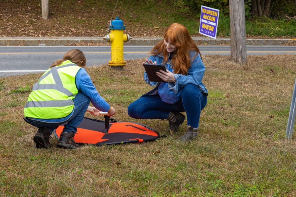
 Appeals Court Upholds Ban on Aerial Mapping by Non-Surveyors A three-judge panel of the 4th U.S. Circuit Court of Appeals has ruled that North Carolina can prohibit the creation of aerial maps by anyone other than licensed land surveyors. This decision affects Michael Jones, a drone operator based in Goldsboro, North Carolina, as well as… Read more: North Carolina Drone Operator to Seek Further Review in First Amendment Lawsuit
 - Pix4D Releases Enhanced PIX4Dcatch 2.0 with AR Features
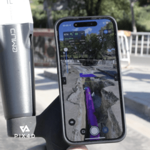
 Latest update integrates professional augmented reality tools for improved precision in AEC sectors. Swiss-based Pix4D, a leading provider of drone and terrestrial mapping solutions, announced today the release of the upgraded version of their mobile scanning app, PIX4Dcatch 2.0. This update introduces augmented reality (AR) capabilities and expands compatibility with various RTK devices, aiming to… Read more: Pix4D Releases Enhanced PIX4Dcatch 2.0 with AR Features
 - SimActive Photogrammetry Software: Enabling Users to Meet Accuracy Standards for Over 20 Years
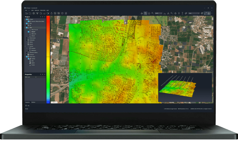
 Mastering Precision: Navigating the Evolving Landscape of Photogrammetry with SimActive SimActive, a Montreal-based photogrammetry software company with over 20 years serving the mapping community. From satellites to aircraft and drones, one software for all acquisition platforms, designed to support all sizes of professional photogrammetry providers. Accuracy standards are crucial in promoting consistency, reliability, and quality… Read more: SimActive Photogrammetry Software: Enabling Users to Meet Accuracy Standards for Over 20 Years
 - Event 38 Unmanned Systems Incorporates Advanced LiDAR Technology into E455 Drone
 Event 38 Unmanned Systems Integrates Advanced LiDAR onto E455 Drone Event 38 Unmanned Systems, a global leader in the manufacturing of unmanned aerial vehicles, has announced a significant upgrade to their Heavy VTOL E455 Drone. The drone can now be equipped with multiple LiDAR systems, including the Resepi Hesai LIDAR XT-32 developed by Inertial Labs.… Read more: Event 38 Unmanned Systems Incorporates Advanced LiDAR Technology into E455 Drone
 - Breaking Barriers: Censys Technologies Soars to New Heights with 30-Mile BVLOS Flight Milestone
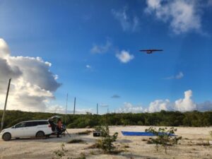
 Censys Technologies Achieves 30-Mile BVLOS Flight Milestone with Sentaero 5 Censys Technologies conducted a 30-mile beyond visual line of sight (BVLOS) operation on November 17th, successfully flying the Sentaero 5 over a cellular network in South Florida adjacent to Lake Okeechobee. This milestone was achieved by leveraging a performance-based, non-geo constrained shielded operations waiver, marking… Read more: Breaking Barriers: Censys Technologies Soars to New Heights with 30-Mile BVLOS Flight Milestone
 - Skydio, Trimble Partner to Bring Centimeter Level Accuracy to the X10

 Skydio and Trimble Collaborate on New Integration for Utilities, Construction and State Transportation Agencies by DRONELIFE Staff Writer Ian J. McNabb Skydio, a California-based drone and UAV manufacturer focused on autonomy, recently announced a new strategic partnership with Trimble to create new integrated workflows designed to unite data capture, data visualization, and data analytics for… Read more: Skydio, Trimble Partner to Bring Centimeter Level Accuracy to the X10
 - GeoCue Partners with Tediris to Integrate TrueView 3D Imaging with Aero 4 Drone

 GeoCue and Tediris Solutions Partner to Provide Spain with Aerial Mapping Solutions by DRONELIFE Staff Writer Ian M. Crosby LiDAR mapping leader GeoCue has announced a new partnership with Spanish drone service provider Tediris Solutions. With close to a decade of experience in the UAV market, Tediris Solutions integrates sophisticated sensors, drones, and artificial intelligence… Read more: GeoCue Partners with Tediris to Integrate TrueView 3D Imaging with Aero 4 Drone
 - Virtual Surveyor Releases Newest Version of Smart Drone Surveying Software: Now with Photogrammetry
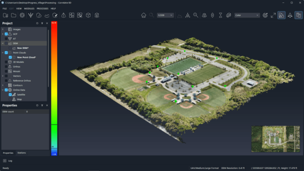
 Virtual Surveyor Releases New Photogrammetry App: Completing Drone Survey Workflow Continue reading below, or listen: DroneLife · Virtual – Surveyor – Adds – Photogrammetry – To – Drone – Surveying – Package by DRONELIFE Staff Writer Ian M. Crosby Software company Virtual Surveyor has updated the newest version of its smart drone surveying software to… Read more: Virtual Surveyor Releases Newest Version of Smart Drone Surveying Software: Now with Photogrammetry
 - Inspecting Wind Turbines Without Stopping Them: Japanese Company Demos Drone Technology
 This article published in collaboration with JUIDA, the Japan UAS Industrial Development Association Japanese Company Showcases First Non-Stop Wind Turbine Inspection Technology Using Drones by DRONELIFE Staff Writer Ian J. McNabb At the Tsukaba Forum recently held in Japan, Tokyo-based Nippon Telegraph and Telephone Corporation (NTT) recently unveiled new technology for inspecting wind turbines without… Read more: Inspecting Wind Turbines Without Stopping Them: Japanese Company Demos Drone Technology
 - Mapping Paradise: Event 38 and PLACE Partner to Map Turks and Caicos
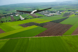
 Event 38 and PLACE Partner to Map Turks and Caicos Islands Using E400 Drones by DRONELIFE Staff Writer Ian M. Crosby Mapping drone manufacturer Event 38 Unmanned Systems has announced the successful deployment of its E400 fixed-wing mapping drone for the collection of aerial imagery and mapping data in Turks and Caicos, which had not… Read more: Mapping Paradise: Event 38 and PLACE Partner to Map Turks and Caicos
 - New eVTOL Fixed Wing from DeltaQuad: Expanded Flight Times, Flexible Payloads, and a Lower Cost
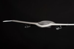
 New eVTOL Fixed Wing from DeltaQuad Surpasses Limits of UAV Performance by DRONELIFE Staff Writer Ian M. Crosby Dutch drone manufacturer DeltaQuad has begun the public beta phase for its Evo model, a new Vertical Takeoff and Landing capable fixed wing electric UAV developed for mapping, inspection, and surveillance. Continue reading below, or listen: DroneLife… Read more: New eVTOL Fixed Wing from DeltaQuad: Expanded Flight Times, Flexible Payloads, and a Lower Cost
 - A Plane in a Backpack? WingXpand Joins Techstars Accelerator Program
 Startup WingXpand Selected to Join Techstars Accelerator Program by DRONELIFE Staff Writer Ian M. Crosby St. Louis based drone startup WingXpand has been chosen from a pool of over 600 international companies to join the world-renowned Techstars LA & Space Accelerator, a three-month program ending with a demo day for the tech and investor communities… Read more: A Plane in a Backpack? WingXpand Joins Techstars Accelerator Program
 - Soaring Eagle BVLOS Waiver Enables Cost-Effective and Efficient Inspections
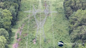 Soaring Eagle Technologies has received another FAA Certificate of Authorization. This BVLOS Waiver enables more efficient inspections. Soaring Eagle Technologies, is a leading drone data collection company working with critical infrastructure companies across the U.S. Having completed over 60 large scale BVLOS missions across the U.S under SGI (special government interest) waivers,the company currently can currently survey… Read more: Soaring Eagle BVLOS Waiver Enables Cost-Effective and Efficient Inspections
 - viDoc Rover and Pix4Dcatch: viDoc RTK Now Available in US and Canada for RTK Accuracy on an iPhone or iPad
 viDoc RTK by Pix4D Launches in USA and Canada by DRONELIFE Staff Writer Ian M. Crosby Photogrammetry solutions leader Pix4D has just released the viDoc RTK rover in the USA and Canada. Previously released in Europe, the German-designed rover connects to the latest iOS devices in order to bring RTK accuracy to terrestrial scanning on… Read more: viDoc Rover and Pix4Dcatch: viDoc RTK Now Available in US and Canada for RTK Accuracy on an iPhone or iPad
 - Photogrammetry is Evolving: Pix4D Announces Pix4Dmatic
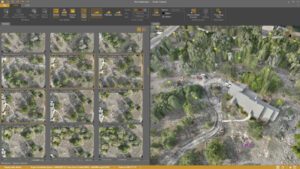
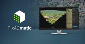 As mapping professionals are called on to map larger and larger areas around the world, photogrammetry software is evolving to meet their needs. Today, Pix4D announces PixDmatic: faster, accurate photogrammetry on a larger scale. “Projects that would have previously been mapped by aircraft are now being surveyed with drones,” says a Pix4D press release. “With… Read more: Photogrammetry is Evolving: Pix4D Announces Pix4Dmatic
 - DJI Drone LiDAR: Introducing Livox and Avia
 “LiDAR is an important piece to the puzzle of accurate models,” said Arjun Menon, DJI’s Engineering Manager, at this morning’s AirWorks keynote. “The challenges of LiDAR have always been in the category of production,” he notes – a highly functioning, lightweight and inexpensive LiDAR appropriate for drone use has been hard to find. “We are… Read more: DJI Drone LiDAR: Introducing Livox and Avia
 - Woolpert Deploys Survey Drones for Colorado DOT
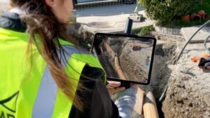
 An architectural/engineering firm is using survey drones to make Colorado highways safer. Engineering firm Felsburg Holt & Ullevig brought in Woolpert to complete drone surveys for a right-of-way project in Castle Rock, Colo. Using a process known as InRoads Terrain Modeling Survey System, the Colorado Department of Transportation project will use the imagery and mapping collected… Read more: Woolpert Deploys Survey Drones for Colorado DOT
 - Orthophoto Survey Drones Help Predict Flash Flooding
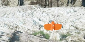
 Orthophoto survey drones are providing new insights to scientists tracking ice and water levels in Alaska. A research team led by Gabriel Wolken of the University of Alaska Fairbank’s Climate Adaptation Science Center has been measuring rising and falling ice and water levels in Suicide Basin glacial lake just outside Juneau. By working to visualize… Read more: Orthophoto Survey Drones Help Predict Flash Flooding
- Skip to main content
- Skip to secondary menu
- Skip to primary sidebar
- Skip to secondary sidebar
- Skip to footer
DRONELIFE
Stay up to date on all the latest Drone News


Footer
SPONSORED