• Skip to main content
  • Skip to secondary menu
  • Skip to primary sidebar
  • Skip to secondary sidebar
  • Skip to footer
  • DroneRacingLife
  • DroneFlyers
  • Newsletter
DroneLife

DRONELIFE

Stay up to date on all the latest Drone News

  • News
  • Products
  • Industries
    • Agriculture
    • Construction
    • Delivery
    • Dual Use
    • Inspection
    • Public Safety
    • Surveying
  • Enthusiasts
  • Regulations
  • Business
  • Video
  • Podcasts

Virtual Surveyor Releases Newest Version of Smart Drone Surveying Software: Now with Photogrammetry

September 26, 2023 by Miriam McNabb 4 Comments

drone surveying, drone survey, photogrammetry
Created with GIMP

Virtual Surveyor Releases New Photogrammetry App: Completing Drone Survey Workflow

Continue reading below, or listen:

DroneLife · Virtual – Surveyor – Adds – Photogrammetry – To – Drone – Surveying – Package

by DRONELIFE Staff Writer Ian M. Crosby

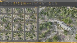
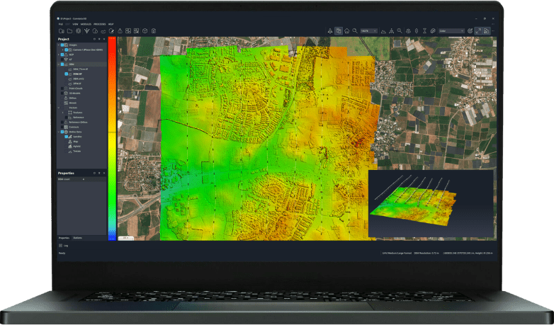
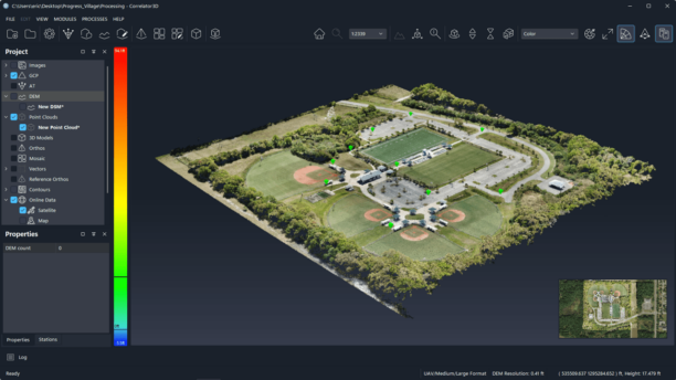
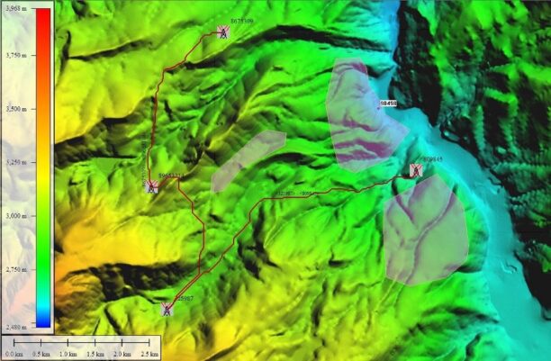
Software company Virtual Surveyor has updated the newest version of its smart drone surveying software to include drone photogrammetry functionality. Photos are processed through the new Terrain Creator app to generate survey-grade terrains to be transferred to the Virtual Surveyor workspace to conduct survey work.

“Virtual Surveyor software is now two desktop apps in one subscription package that create a seamless end-to-end drone survey workflow to save time and money,” said Virtual Surveyor CEO Tom Op ‘t Eyndt. “Terrain Creator removes complexity from the drone photogrammetry process, offering a visual and intuitive application to produce an orthomosaic and digital surface model (DSM) from drone photos.”

Virtual Surveyor software was designed to link drone photogrammetric processing applications and engineering design packages. Prior to this release, users were required to use third-party software to create elevation models and an orthomosaic to be worked on with the Virtual Surveyor toolset to obtain the necessary 3D topographic information.

“Drone surveyors no longer have to spend money on a third-party photogrammetry package to convert their drone photos into an orthomosaic and DSMs,” said Op ‘t Eyndt. “It just comes with our package, and the fully integrated workflow eliminates the time spent porting photogrammetry products from another package into Virtual Surveyor.”

In the Virtual Surveyor desktop app, users can leverage its toolsets to create CAD models, cut-and-fill maps and calculations, or calculate volume reports.

Those already subscribers to Virtual Surveyor Ridge and Peak editions will receive an automatic update to Version 9.0 with Terrain Creator. Additionally, a flexible licensing setup for subscribing organizations will enable two users to access the Terrain Creator and Virtual Surveyor applications at the same time on two different computers.

Virtual Surveyor will showcase its new release at InterGEO 2023 (Hall 1.2, Stand D1.030) on October 10-12 in Berlin, Germany, as well as other trade fairs this autumn.

Read more:

  • Pix4D and Wingtra: New Integration Makes Orthomosaic and Point Cloud Generation 2X Faster
  • Microsoft Collaborates with SimActive to Demonstrate a Cloud Photogrammetry Solution
  • PPK for UAV Photogrammetry: the Optimal Workflow to Reduce GCP [Webinar]
  • NDAA-Compliant LiDAR Drone Surveying System: Microdrones New EasyOne Solution

Ian attended Dominican University of California, where he received a BA in English in 2019. With a lifelong passion for writing and storytelling and a keen interest in technology, he is now contributing to DroneLife as a staff writer.


Miriam McNabb

Miriam McNabb is the Editor-in-Chief of DRONELIFE and CEO of JobForDrones, a professional drone services marketplace, and a fascinated observer of the emerging drone industry and the regulatory environment for drones. Miriam has penned over 3,000 articles focused on the commercial drone space and is an international speaker and recognized figure in the industry.  Miriam has a degree from the University of Chicago and over 20 years of experience in high tech sales and marketing for new technologies.
For drone industry consulting or writing, Email Miriam.

TWITTER:@spaldingbarker

Subscribe to DroneLife here.

Filed Under: Drone News, Drone News Feeds, Drones in the News, Featured - Surveying, Featured – Safety and Security, News, Survey, Surveying Tagged With: drone surveying, drones for CAD, drones for surveying, photogrammetry, virtual surveyor

Reader Interactions

Trackbacks

  1. Virtual Surveyor Releases Newest Version of Smart Drone Surveying Software: Now with Photogrammetry – WELCOME ON Dronestag Blog says:
    September 27, 2023 at 7:39 am

    […] More… […]

    Reply
  2. Virtual Surveyor Releases Newest Version of Smart Drone Surveying Software: Now with Photogrammetry - Worldnews4 says:
    September 27, 2023 at 4:52 am

    […] Miriam McNabb is the Editor-in-Chief of DRONELIFE and CEO of JobForDrones, a professional drone services marketplace, and a fascinated observer of the emerging drone industry and the regulatory environment for drones. Miriam has penned over 3,000 articles focused on the commercial drone space and is an international speaker and recognized figure in the industry.  Miriam has a degree from the University of Chicago and over 20 years of experience in high tech sales and marketing for new technologies.For drone industry consulting or writing, Email Miriam. […]

    Reply
  3. Digital Surveyor Drone Surveying Software program - techwithtrends.com says:
    September 27, 2023 at 12:59 am

    […] Supply hyperlink […]

    Reply
  4. Digital Surveyor Drone Surveying Software program – Best Life From Home says:
    September 26, 2023 at 11:45 am

    […] Supply hyperlink […]

    Reply

Leave a Reply Cancel reply

Your email address will not be published. Required fields are marked *

Primary Sidebar

LATEST

FCC Proposes New Spectrum Rules to Advance Air Mobility Technologies

Updated Guidelines Aim to Enhance Safety, Innovation, and Growth in Crewed and Uncrewed Aviation The Federal Communications Commission (FCC) has…

Continue Reading FCC Proposes New Spectrum Rules to Advance Air Mobility Technologies

DJI Expands Beyond Drones with New Super-Fast Chargers for Power Storage Systems

Innovative car and solar chargers join the DJI Power Series, offering solutions for RVs, vehicles, and emergency backup systems. by…

Continue Reading DJI Expands Beyond Drones with New Super-Fast Chargers for Power Storage Systems

Windracers Introduces ULTRA MK2 Cargo UAV: More Power, Payload, and Efficiency

A New Chapter for Autonomous Middle-Mile Logistics Windracers has unveiled its latest self-flying cargo aircraft, the ULTRA MK2, at a…

Continue Reading Windracers Introduces ULTRA MK2 Cargo UAV: More Power, Payload, and Efficiency

Inside Ascent AeroSystems: A Revolutionary Approach to Drones

Coaxial Innovation from Massachusetts Massachusetts-based Ascent AeroSystems offers something unique in the crowded drone market. During a recent visit to…

Continue Reading Inside Ascent AeroSystems: A Revolutionary Approach to Drones

Hempstead Police Department Introduces Drone-As-First-Responder System from Flock Safety

New Technology Aims to Enhance Emergency Response Times The Hempstead Police Department announced plans to deploy a new Drone-as-First-Responder (DFR)…

Continue Reading Hempstead Police Department Introduces Drone-As-First-Responder System from Flock Safety

SkySwap Program: A New Path for Public Safety Drone Compliance

Axon Introduces Drone Swap Program to Help Agencies Transition to Secure, American-Made Drone Technology Public safety agencies in the U.S.…

Continue Reading SkySwap Program: A New Path for Public Safety Drone Compliance

Pioneering the Skies: UAE Approves First Commercial Vertiport for Air Taxis

Dubai’s DXV Facility Sets the Stage for Advanced Air Mobility with Skyports and GCAA’s Vision for Urban Transport Transformation by…

Continue Reading Pioneering the Skies: UAE Approves First Commercial Vertiport for Air Taxis

Drone Nerds Expands Support for American Farmers with ABZ Innovation Partnership

Collaboration Brings Advanced Agriculture Drones to U.S. Market Drone Nerds, a leading provider of enterprise and agricultural drones, has partnered…

Continue Reading Drone Nerds Expands Support for American Farmers with ABZ Innovation Partnership

Closing the Gaps: Why Low-Altitude Airspace Awareness Is Critical for the Future of Aviation

The recent New Jersey drone panic has made it clear: people want to know what’s flying in low altitude airspace.…

Continue Reading Closing the Gaps: Why Low-Altitude Airspace Awareness Is Critical for the Future of Aviation

Addressing Noise Concerns: A Key to Community Acceptance of Drone Delivery Technology

DEXA’s NEPA Testing Highlights Noise Mitigation and Environmental Responsibilit Noise is a major concern for consumers and a critical factor…

Continue Reading Addressing Noise Concerns: A Key to Community Acceptance of Drone Delivery Technology

Secondary Sidebar

Footer

SPONSORED

Inspired Flight Gremsy IF800 VIO F1 drones geo week

What Will It Take to Strengthen U.S. Drone Manufacturing? A Conversation with Inspired Flight’s CEO

Global Mapper Mobile data collection

Collection Ground Control Points with Global Mapper Mobile

Military Drone Mapping Solutions

How SimActive’s Correlator3D™ is Revolutionizing Military Mapping: An Exclusive Interview with CEO Philippe Simard

Photogrammetry Accuracy Standards

SimActive Photogrammetry Software: Enabling Users to Meet Accuracy Standards for Over 20 Years

NACT Engineering Parrot ANAFI tether indoor shot

Smart Tether for Parrot ANAFI USA from NACT Engineering

Blue Marble, features global mapper, features Blue Marble

Check Out These New Features in Global Mapper v25 from Blue Marble

About Us | Contact Us | Advertise With Us | Write for Us | Privacy Policy | Terms of Service

The Trusted Source for the Business of Drones.

This website uses cookies and third party services. By clicking OK, you are agreeing to our privacy policy. ACCEPT

Manage consent

Privacy Overview

This website uses cookies to improve your experience while you navigate through the website. Out of these, the cookies that are categorized as necessary are stored on your browser as they are essential for the working of basic functionalities of the website. We also use third-party cookies that help us analyze and understand how you use this website. These cookies will be stored in your browser only with your consent. You also have the option to opt-out of these cookies. But opting out of some of these cookies may affect your browsing experience.
Necessary
Always Enabled
Necessary cookies are absolutely essential for the website to function properly. These cookies ensure basic functionalities and security features of the website, anonymously.
CookieDurationDescription
cookielawinfo-checkbox-analytics11 monthsThis cookie is set by GDPR Cookie Consent plugin. The cookie is used to store the user consent for the cookies in the category "Analytics".
cookielawinfo-checkbox-functional11 monthsThe cookie is set by GDPR cookie consent to record the user consent for the cookies in the category "Functional".
cookielawinfo-checkbox-necessary11 monthsThis cookie is set by GDPR Cookie Consent plugin. The cookies is used to store the user consent for the cookies in the category "Necessary".
cookielawinfo-checkbox-others11 monthsThis cookie is set by GDPR Cookie Consent plugin. The cookie is used to store the user consent for the cookies in the category "Other.
cookielawinfo-checkbox-performance11 monthsThis cookie is set by GDPR Cookie Consent plugin. The cookie is used to store the user consent for the cookies in the category "Performance".
viewed_cookie_policy11 monthsThe cookie is set by the GDPR Cookie Consent plugin and is used to store whether or not user has consented to the use of cookies. It does not store any personal data.
Functional
Functional cookies help to perform certain functionalities like sharing the content of the website on social media platforms, collect feedbacks, and other third-party features.
Performance
Performance cookies are used to understand and analyze the key performance indexes of the website which helps in delivering a better user experience for the visitors.
Analytics
Analytical cookies are used to understand how visitors interact with the website. These cookies help provide information on metrics the number of visitors, bounce rate, traffic source, etc.
Advertisement
Advertisement cookies are used to provide visitors with relevant ads and marketing campaigns. These cookies track visitors across websites and collect information to provide customized ads.
Others
Other uncategorized cookies are those that are being analyzed and have not been classified into a category as yet.
SAVE & ACCEPT