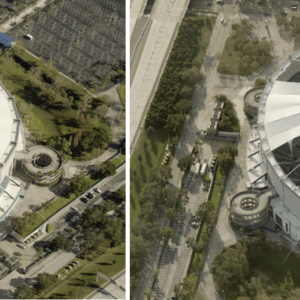
EagleView produces high-resolution images in the wake of disasters By DRONELIFE Features Editor Jim Magill Soon after two powerful and devastating hurricanes, Helene and Milton, struck Florida within weeks of each other last fall, data analytics company EagleView Technologies was on the scene, capturing high-resolution aerial images of the destruction to aid recovery efforts … [Read more...] about EagleView’s High-Tech Response to Natural Disasters: Capturing Devastation from Above
disaster response
Spexi Secures $11.5M Series A to Expand Ultra-High-Resolution Drone Imagery Network

Transforming Earth Imagery for Emergency Response, AI, and Emerging Technologies Spexi, a Vancouver-based technology company, has announced the completion of its $11.5 million USD Series A funding round, led by Blockchange Ventures. This milestone will support Spexi’s goal of building a scalable global network of drone pilots to deliver standardized, ultra-high-resolution … [Read more...] about Spexi Secures $11.5M Series A to Expand Ultra-High-Resolution Drone Imagery Network
Drones Transform Emergency Response with Advanced Communication Technology [VIDEO]

AERIAL Research Project Develops Groundbreaking UAS Communication Systems The AERIAL research project, a collaboration between VTT Technical Research Centre of Finland and New York University Tandon School of Engineering, is advancing drone technology to enhance urban safety and emergency response. This three-year project, concluding in December 2024, focuses on creating … [Read more...] about Drones Transform Emergency Response with Advanced Communication Technology [VIDEO]
Drones Aid Disaster Recovery: Mapping and Photogrammetry Support Hurricane Helene Relief Efforts
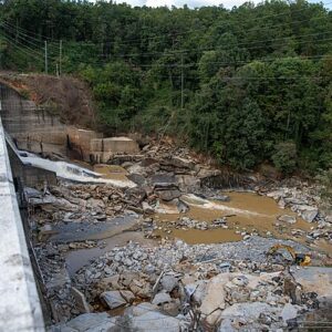
Drone mapping, photogrammetry aid recovery in wake of Helene devastation By DRONELIFE Features Editor Jim Magill (Part of a series on the drone community’s response to natural disasters) Hurricane Helene, the massive and deadly storm that tore through a large swath of the U.S. Southeast in late September, triggered a tremendous response from the drone-flying community, as … [Read more...] about Drones Aid Disaster Recovery: Mapping and Photogrammetry Support Hurricane Helene Relief Efforts
How Drones Transformed Volcanic Eruption Management in Iceland: the Video Case Study from DJI
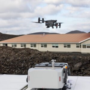
From Monitoring to Search and Rescue, Discover How DJI Dock and Matrice 30 Enhanced Safety and Efficiency During Reykjanes Peninsula Eruption Check out this video case study from DJI: Iceland Volcano Drone Monitoring Since 2021, drones have played a crucial role in monitoring volcanic eruptions on Iceland's Reykjanes Peninsula. These versatile tools have been … [Read more...] about How Drones Transformed Volcanic Eruption Management in Iceland: the Video Case Study from DJI


