• Skip to main content
  • Skip to secondary menu
  • Skip to primary sidebar
  • Skip to secondary sidebar
  • Skip to footer
  • DroneRacingLife
  • DroneFlyers
  • Newsletter
DroneLife

DRONELIFE

Stay up to date on all the latest Drone News

  • News
  • Products
  • Industries
    • Agriculture
    • Construction
    • Delivery
    • Dual Use
    • Inspection
    • Public Safety
    • Surveying
  • Enthusiasts
  • Regulations
  • Business
  • Video
  • Podcasts

Colorizing Lidar: SimActive and LiDARUSA Partner

February 27, 2023 by Miriam McNabb 8 Comments

Colorized Lidar
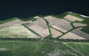
Light Detection and Ranging (Lidar) imagery offers high resolution models of ground elevation, with vertical accuracy.  As  Lidar sensors have gotten smaller and lighter for use on drones, the use cases have expanded. Lidar imagery is flexible and precise, which makes it useful for professionals who want to understand a surface.  With Lidar, users can see the ground beneath the tree cover, or with Bathymetric LiDAR, the riverbed beneath the water.  Lidar’s high resolution maps are used for applications that range from archeology to disaster management.

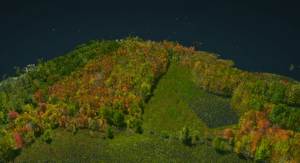
Lidar data can be tricky to understand, however.  Without the context of traditional imagery, Lidar requires users to interpret what they are seeing.  Lidar scanners don’t typically capture color, including only elevation or intensity values.

colorized LidarSimActive Software Used to Colorize Lidar

 Now, SimActive Inc. announces the use of its lidar point cloud colorization capabilities by users of multi-sensor systems developed by LiDARUSA. SimActive’s Correlator3D™ software allows to profit from imagery and Lidar data in a complimentary fashion: making Lidar data easy to understand.

Lidar point clouds are first imported in Correlator3D™, to which the collected imagery is automatically registered.  The lidar data are used as control for the registration process.  Each lidar point is then colorized using the images.

“While lidar is great, everyone understands imagery. Colorizing lidar makes the data much more understandable”, said Jeff Fagerman, CEO at LiDARUSA.  “Correlator3D allows our clients to easily colorize lidar point clouds from their multi-camera system.”

SimActive is the developer of Correlator3D™ software, a patented end-to-end photogrammetry solution for the generation of high-quality geospatial data from satellite and aerial imagery, including drones.

Read more:

  • From the floor of Intergeo: Simactive, Mapping Spaces from Countries to Construction Sites
  • SimActive and Phase One IIQ Integration: Faster Processing, Easier Data Management
  • Drone Mapping in Construction: SimActives Correlator 3D in the Field in Texas
  • Creating Colorized Point Clouds, Reflective Calibration, and More: Diving into SimActives New Features
  • Mapping and LiDAR: SimActive Integrated with LiDAR Solution for Drones


Miriam McNabb

Miriam McNabb is the Editor-in-Chief of DRONELIFE and CEO of JobForDrones, a professional drone services marketplace, and a fascinated observer of the emerging drone industry and the regulatory environment for drones. Miriam has penned over 3,000 articles focused on the commercial drone space and is an international speaker and recognized figure in the industry.  Miriam has a degree from the University of Chicago and over 20 years of experience in high tech sales and marketing for new technologies.
For drone industry consulting or writing, Email Miriam.

TWITTER:@spaldingbarker

Subscribe to DroneLife here.

Filed Under: Drone News, Drone News Feeds, Drones in the News, News

Reader Interactions

Trackbacks

  1. Drone Information of the Week March 3 - Shikazu.co.uk says:
    March 5, 2023 at 1:07 pm

    […] Colorizing Lidar: SimActive and LiDARUSA Accomplice […]

    Reply
  2. Drone Information of the Week March 3 - Shahoon.com says:
    March 5, 2023 at 12:29 pm

    […] Colorizing Lidar: SimActive and LiDARUSA Spouse […]

    Reply
  3. Veckans drönarenyheter 3 mars - Tjänadeg says:
    March 4, 2023 at 4:17 am

    […] Colorizing Lidar: SimActive och LiDARUSA Accomplice […]

    Reply
  4. Drone Information of the Week March 3 - Natli Tech says:
    March 3, 2023 at 9:20 am

    […] Colorizing Lidar: SimActive and LiDARUSA Companion […]

    Reply
  5. Drone Information of the Week March 3 - Thrive How says:
    March 3, 2023 at 6:55 am

    […] Colorizing Lidar: SimActive and LiDARUSA Associate […]

    Reply
  6. Colorizing Lidar: SimActive and LiDARUSA Partner says:
    February 28, 2023 at 9:17 pm

    […] More… […]

    Reply
  7. Colorizing Lidar: SimActive and LiDARUSA Partner - Fantastin says:
    February 27, 2023 at 11:26 pm

    […] Source link […]

    Reply
  8. Colorizing Lidar: SimActive and LiDARUSA Partner Miriam McNabb — DRONELIFE – Romulan News Channel says:
    February 27, 2023 at 4:15 pm

    […] […]

    Reply

Leave a Reply Cancel reply

Your email address will not be published. Required fields are marked *

Primary Sidebar

LATEST

FCC Proposes New Spectrum Rules to Advance Air Mobility Technologies

Updated Guidelines Aim to Enhance Safety, Innovation, and Growth in Crewed and Uncrewed Aviation The Federal Communications Commission (FCC) has…

Continue Reading FCC Proposes New Spectrum Rules to Advance Air Mobility Technologies

DJI Expands Beyond Drones with New Super-Fast Chargers for Power Storage Systems

Innovative car and solar chargers join the DJI Power Series, offering solutions for RVs, vehicles, and emergency backup systems. by…

Continue Reading DJI Expands Beyond Drones with New Super-Fast Chargers for Power Storage Systems

Windracers Introduces ULTRA MK2 Cargo UAV: More Power, Payload, and Efficiency

A New Chapter for Autonomous Middle-Mile Logistics Windracers has unveiled its latest self-flying cargo aircraft, the ULTRA MK2, at a…

Continue Reading Windracers Introduces ULTRA MK2 Cargo UAV: More Power, Payload, and Efficiency

Inside Ascent AeroSystems: A Revolutionary Approach to Drones

Coaxial Innovation from Massachusetts Massachusetts-based Ascent AeroSystems offers something unique in the crowded drone market. During a recent visit to…

Continue Reading Inside Ascent AeroSystems: A Revolutionary Approach to Drones

Hempstead Police Department Introduces Drone-As-First-Responder System from Flock Safety

New Technology Aims to Enhance Emergency Response Times The Hempstead Police Department announced plans to deploy a new Drone-as-First-Responder (DFR)…

Continue Reading Hempstead Police Department Introduces Drone-As-First-Responder System from Flock Safety

SkySwap Program: A New Path for Public Safety Drone Compliance

Axon Introduces Drone Swap Program to Help Agencies Transition to Secure, American-Made Drone Technology Public safety agencies in the U.S.…

Continue Reading SkySwap Program: A New Path for Public Safety Drone Compliance

Pioneering the Skies: UAE Approves First Commercial Vertiport for Air Taxis

Dubai’s DXV Facility Sets the Stage for Advanced Air Mobility with Skyports and GCAA’s Vision for Urban Transport Transformation by…

Continue Reading Pioneering the Skies: UAE Approves First Commercial Vertiport for Air Taxis

Drone Nerds Expands Support for American Farmers with ABZ Innovation Partnership

Collaboration Brings Advanced Agriculture Drones to U.S. Market Drone Nerds, a leading provider of enterprise and agricultural drones, has partnered…

Continue Reading Drone Nerds Expands Support for American Farmers with ABZ Innovation Partnership

Closing the Gaps: Why Low-Altitude Airspace Awareness Is Critical for the Future of Aviation

The recent New Jersey drone panic has made it clear: people want to know what’s flying in low altitude airspace.…

Continue Reading Closing the Gaps: Why Low-Altitude Airspace Awareness Is Critical for the Future of Aviation

Addressing Noise Concerns: A Key to Community Acceptance of Drone Delivery Technology

DEXA’s NEPA Testing Highlights Noise Mitigation and Environmental Responsibilit Noise is a major concern for consumers and a critical factor…

Continue Reading Addressing Noise Concerns: A Key to Community Acceptance of Drone Delivery Technology

Secondary Sidebar

Footer

SPONSORED

Inspired Flight Gremsy IF800 VIO F1 drones geo week

What Will It Take to Strengthen U.S. Drone Manufacturing? A Conversation with Inspired Flight’s CEO

Global Mapper Mobile data collection

Collection Ground Control Points with Global Mapper Mobile

Military Drone Mapping Solutions

How SimActive’s Correlator3D™ is Revolutionizing Military Mapping: An Exclusive Interview with CEO Philippe Simard

Photogrammetry Accuracy Standards

SimActive Photogrammetry Software: Enabling Users to Meet Accuracy Standards for Over 20 Years

NACT Engineering Parrot ANAFI tether indoor shot

Smart Tether for Parrot ANAFI USA from NACT Engineering

Blue Marble, features global mapper, features Blue Marble

Check Out These New Features in Global Mapper v25 from Blue Marble

About Us | Contact Us | Advertise With Us | Write for Us | Privacy Policy | Terms of Service

The Trusted Source for the Business of Drones.

This website uses cookies and third party services. By clicking OK, you are agreeing to our privacy policy. ACCEPT

Manage consent

Privacy Overview

This website uses cookies to improve your experience while you navigate through the website. Out of these, the cookies that are categorized as necessary are stored on your browser as they are essential for the working of basic functionalities of the website. We also use third-party cookies that help us analyze and understand how you use this website. These cookies will be stored in your browser only with your consent. You also have the option to opt-out of these cookies. But opting out of some of these cookies may affect your browsing experience.
Necessary
Always Enabled
Necessary cookies are absolutely essential for the website to function properly. These cookies ensure basic functionalities and security features of the website, anonymously.
CookieDurationDescription
cookielawinfo-checkbox-analytics11 monthsThis cookie is set by GDPR Cookie Consent plugin. The cookie is used to store the user consent for the cookies in the category "Analytics".
cookielawinfo-checkbox-functional11 monthsThe cookie is set by GDPR cookie consent to record the user consent for the cookies in the category "Functional".
cookielawinfo-checkbox-necessary11 monthsThis cookie is set by GDPR Cookie Consent plugin. The cookies is used to store the user consent for the cookies in the category "Necessary".
cookielawinfo-checkbox-others11 monthsThis cookie is set by GDPR Cookie Consent plugin. The cookie is used to store the user consent for the cookies in the category "Other.
cookielawinfo-checkbox-performance11 monthsThis cookie is set by GDPR Cookie Consent plugin. The cookie is used to store the user consent for the cookies in the category "Performance".
viewed_cookie_policy11 monthsThe cookie is set by the GDPR Cookie Consent plugin and is used to store whether or not user has consented to the use of cookies. It does not store any personal data.
Functional
Functional cookies help to perform certain functionalities like sharing the content of the website on social media platforms, collect feedbacks, and other third-party features.
Performance
Performance cookies are used to understand and analyze the key performance indexes of the website which helps in delivering a better user experience for the visitors.
Analytics
Analytical cookies are used to understand how visitors interact with the website. These cookies help provide information on metrics the number of visitors, bounce rate, traffic source, etc.
Advertisement
Advertisement cookies are used to provide visitors with relevant ads and marketing campaigns. These cookies track visitors across websites and collect information to provide customized ads.
Others
Other uncategorized cookies are those that are being analyzed and have not been classified into a category as yet.
SAVE & ACCEPT