• Skip to main content
  • Skip to secondary menu
  • Skip to primary sidebar
  • Skip to secondary sidebar
  • Skip to footer
  • DroneRacingLife
  • DroneFlyers
  • Newsletter
DroneLife

DRONELIFE

Stay up to date on all the latest Drone News

  • News
  • Products
  • Industries
    • Agriculture
    • Construction
    • Delivery
    • Dual Use
    • Inspection
    • Public Safety
    • Surveying
  • Enthusiasts
  • Regulations
  • Business
  • Video
  • Podcasts

Surveyors Wanted to Shut this Drone Photographer Down. Now, He’s Fighting Back. [VIDEO]

March 23, 2021 by Miriam McNabb 22 Comments

drone mapping surveyingIs drone mapping surveying without a license?  A First Amendment lawsuit in North Carolina says surveyors cannot stop drone operators from selling photos and making maps.

Hiring a surveyor is an expensive buisness, but necessary if you want to establish legal property lines.  What if you just want to see what your property looks like, or create a visual map of your property or work place in order to help make decisions about new development or see what type of topography you have?  While previously, you may have had to hire surveyors to make a map, now that information is readily available by using aerial images.  Commonly available commercial drone software is designed to do exactly this: creating orthomosaic maps and 3D images.

Surveyers apparently don’t like the competition. In North Carolina, they’re trying to push drone operators out of business.  “…drone entrepreneurs on the cutting edge are finding a very old industry standing in the way: land surveying. In North Carolina, the Board of Examiners for Engineers and Surveyors [the NC Board] sends warnings to drone operators saying that certain photography amounts to surveying without a license and threatens them with possible criminal prosecution.”

If most commercial drone mapping – photos that include GPS information and/or measurements – amounts to “surveying without a license” then the NC Board is going to have their work cut out for them.  That premise would require law enforcement teams using drone imagery to analyze accident scenes, Departments of Transportation using drone imagery for disaster response, and countless other commercial drone customers to get surveying licenses – which apparently is what the NC Board wants.

The Lawsuit

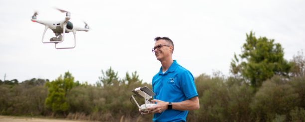
Michael Jones is photographer and videographer from North Carolina who expanded into drone imagery about five years ago. Jones takes aerial images for customers for a wide variety of purposes: real estate, property management and inspection, and marketing.  When requested, Jones processes aerial images to create orthomosaics – as do thousands of drone operators around the country: drone mapping platform DroneDeploy alone has more than 5,000 customers, Pix4D, SimActive, and others have thousands more.

It was not until he received a warning letter from the Board in December 2018 that Michael had any idea that what he was doing could be considered “surveying.” He had always been careful to note that his work did not establish property lines and could not be used for legal purposes. But a Board investigator told him that providing images with any metadata (information about GPS coordinates, elevation, or distance) or that stitching together images qualified as surveying and required a full-blown, state-issued license. Worried about the Board’s threat that he could be fined or even criminally prosecuted, Michael shut down much of his drone business.

“When the surveying board wrote that I was breaking the law, I could hardly believe it,” said Jones. “I didn’t think that I was doing anything that could be considered surveying. In fact, I don’t know of any surveying company that was using drones like I was.”

It may seem unfair and unreasonable, but the intimidation works: most drone entrepreneurs can’t afford to take the chance of a lawsuit. Now, with the support of the Institute of Justice [IJ], Michael Jones is fighting back. “The images and maps that Michael was creating for willing customers were not being used to set legal boundaries; they were purely for informational purposes,” says an IJ press release. “And creating and sharing information is speech protected by the First Amendment. ”  (Read the complaint here.)

“I really hope a successful lawsuit can prevent drone photographers all over the country from being targeted by their state surveying boards. There’s a lot of people doing innovative work, but that could come to a halt if a legacy industry stands in the way,” Jones tells DRONELIFE.

“Drone technology may be new, but the principles at stake in Michael’s case are as old as the nation itself,” said Sam Gedge, an attorney with the Institute for Justice. “Taking photos and providing information to willing clients isn’t ‘surveying’; it’s speech, and it’s protected by the First Amendment.”

“This is just the newest example of a licensing board expanding its authority to crack down on competition,” said IJ Attorney James Knight. “But licensing boards should not be able to use their authority just to protect businesses from competition. The government should step out of the way and let innovative businesses like Michael’s continue serving their customers.”

Drone mapping isn’t surveying for the vast majority of cases – but it could be.  Instead of trying to shut him down, surveyors should be hiring Michael to train them.  Drones can be a fantastic tool for surveyors, saving them time, money and physical work.  Surveyors won’t be able to beat ’em, they should be moving as fast as possible to join ’em.

Miriam McNabb

Miriam McNabb is the Editor-in-Chief of DRONELIFE and CEO of JobForDrones, a professional drone services marketplace, and a fascinated observer of the emerging drone industry and the regulatory environment for drones. Miriam has penned over 3,000 articles focused on the commercial drone space and is an international speaker and recognized figure in the industry.  Miriam has a degree from the University of Chicago and over 20 years of experience in high tech sales and marketing for new technologies.
For drone industry consulting or writing, Email Miriam.

TWITTER:@spaldingbarker

Subscribe to DroneLife here.

Filed Under: Drone News Feeds, Featured, News Tagged With: aerial photographers, drone surveying, first amendment rights, Surveying

Reader Interactions

Trackbacks

  1. North Carolina Takes Aim at Drones - But Hits Free Speech - MyWealth -OptimismArcher says:
    April 11, 2021 at 1:05 am

    […] reported earlier on a lawsuit in North Carolina challenging the notion that drone mapping is surveying without a license.  Here, […]

    Reply
  2. North Carolina Takes Aim at Drones – But Hits Free Speech - kameratalk.com says:
    April 10, 2021 at 7:30 pm

    […] reported earlier on a lawsuit in North Carolina challenging the notion that drone mapping is surveying without a license.  Here, […]

    Reply
  3. North Carolina Takes Aim at Drones – But Hits Free Speech – Home Town Buy says:
    April 10, 2021 at 9:26 am

    […] reported earlier on a lawsuit in North Carolina difficult the notion that drone mapping is surveying with out a license.  Right […]

    Reply
  4. North Carolina Takes Aim at Drones – But Hits Free Speech | taktik(z) GDI (Government Defense Infrastructure) says:
    April 10, 2021 at 7:40 am

    […] reported earlier on a lawsuit in North Carolina challenging the notion that drone mapping is surveying without a license. […]

    Reply
  5. North Carolina Takes Aim at Drones – But Hits Free Speech - The Drone Page says:
    April 10, 2021 at 6:26 am

    […] reported earlier on a lawsuit in North Carolina challenging the notion that drone mapping is surveying without a license.  Here, […]

    Reply
  6. North Carolina Takes Aim at Drones – But Hits Free Speech | Drone Films Limited says:
    April 10, 2021 at 6:17 am

    […] reported earlier on a lawsuit in North Carolina challenging the notion that drone mapping is surveying without a license. […]

    Reply
  7. North Carolina Takes Aim at Drones – But Hits Free Speech - Summer Of Drones News says:
    April 10, 2021 at 6:14 am

    […] reported earlier on a lawsuit in North Carolina difficult the notion that drone mapping is surveying with out a license. […]

    Reply
  8. Drone Operator Sues North Carolina Over Its First Amendment-Violating Surveyor Licensing Laws - On Sale Drones says:
    March 30, 2021 at 1:31 am

    […] Here’s the impetus of the lawsuit being brought by photographer Michael Jones, as summarized by Miriam McNabb of Drone Life: […]

    Reply
  9. Drone Operator Sues North Carolina Over Its First Amendment-Violating Surveyor Licensing Laws | Love Africa News says:
    March 29, 2021 at 7:10 pm

    […] Here’s the impetus of the lawsuit being brought by photographer Michael Jones, as summarized by Miriam McNabb of Drone Life: […]

    Reply
  10. Drone Operator Sues North Carolina Over Its First Amendment-Violating Surveyor Licensing Laws – Exaltop says:
    March 29, 2021 at 5:48 pm

    […] Here’s the impetus of the lawsuit being brought by photographer Michael Jones, as summarized by Miriam McNabb of Drone Life: […]

    Reply
  11. eCARTO News March 2021 International Cartographic Association says:
    March 29, 2021 at 11:53 am

    […] Surveyors Wanted to Shut this Drone Photographer Down. Now, He’s Fighting Back. – dronelife.com […]

    Reply
  12. Is Drone Mapping Surveying without License? – Dronestagram Blog says:
    March 27, 2021 at 5:02 pm

    […] More… […]

    Reply
  13. Is Drone Mapping Surveying without License? - Go Drones Blog says:
    March 24, 2021 at 9:09 am

    […] Is drone mapping surveying without a license? NC drone photographer fights back after local Surveying Board threatens him with prosecution. Source […]

    Reply
  14. Is Drone Mapping Surveying without License? – Game of Drones says:
    March 24, 2021 at 1:49 am

    […] Article Source […]

    Reply
  15. Surveyors Wanted to Shut this Drone Photographer Down for Providing Aerial Photographs. Now, He’s Fighting Back. [VIDEO] - kameratalk.com says:
    March 24, 2021 at 1:10 am

    […] Source […]

    Reply
  16. Surveyors Wanted to Shut this Drone Photographer Down for Providing Aerial Photographs. Now, He’s Fighting Back. [VIDEO] – Top Drones & reviews says:
    March 23, 2021 at 11:03 pm

    […] post Surveyors Wanted to Shut this Drone Photographer Down for Providing Aerial Photographs. Now, He’s … appeared first on […]

    Reply
  17. Surveyors Wanted to Shut this Drone Photographer Down for Providing Aerial Photographs. Now, He’s Fighting Back. [VIDEO] - On Sale Drones says:
    March 23, 2021 at 10:32 pm

    […] Source […]

    Reply
  18. Surveyors Wanted to Shut this Drone Photographer Down for Providing Aerial Photographs. Now, He’s Fighting Back. [VIDEO] – DronePilots.News says:
    March 23, 2021 at 4:23 pm

    […] Source […]

    Reply
  19. Surveyors Wanted to Shut this Drone Photographer Down for Providing Aerial Photographs. Now, He’s Fighting Back. [VIDEO] | Drone Magazine says:
    March 23, 2021 at 3:25 pm

    […] Source […]

    Reply
  20. Surveyors Wanted to Shut this Drone Photographer Down for Providing Aerial Photographs. Now, He’s Fighting Back. [VIDEO] – DronePilots.News says:
    March 23, 2021 at 1:26 pm

    […] post Surveyors Wanted to Shut this Drone Photographer Down for Providing Aerial Photographs. Now, He’s … appeared first on […]

    Reply
  21. Surveyors Wanted to Shut this Drone Photographer Down for Providing Aerial Photographs. Now, He’s Fighting Back. [VIDEO] – Best Drones Online says:
    March 23, 2021 at 1:13 pm

    […] post Surveyors Wanted to Shut this Drone Photographer Down for Providing Aerial Photographs. Now, He’s … appeared first on […]

    Reply
  22. Is Drone Mapping Surveying without License? – Drone Observer says:
    March 23, 2021 at 12:56 pm

    […] Source link […]

    Reply

Leave a Reply Cancel reply

Your email address will not be published. Required fields are marked *

Primary Sidebar

LATEST

FCC Proposes New Spectrum Rules to Advance Air Mobility Technologies

Updated Guidelines Aim to Enhance Safety, Innovation, and Growth in Crewed and Uncrewed Aviation The Federal Communications Commission (FCC) has…

Continue Reading FCC Proposes New Spectrum Rules to Advance Air Mobility Technologies

DJI Expands Beyond Drones with New Super-Fast Chargers for Power Storage Systems

Innovative car and solar chargers join the DJI Power Series, offering solutions for RVs, vehicles, and emergency backup systems. by…

Continue Reading DJI Expands Beyond Drones with New Super-Fast Chargers for Power Storage Systems

Windracers Introduces ULTRA MK2 Cargo UAV: More Power, Payload, and Efficiency

A New Chapter for Autonomous Middle-Mile Logistics Windracers has unveiled its latest self-flying cargo aircraft, the ULTRA MK2, at a…

Continue Reading Windracers Introduces ULTRA MK2 Cargo UAV: More Power, Payload, and Efficiency

Inside Ascent AeroSystems: A Revolutionary Approach to Drones

Coaxial Innovation from Massachusetts Massachusetts-based Ascent AeroSystems offers something unique in the crowded drone market. During a recent visit to…

Continue Reading Inside Ascent AeroSystems: A Revolutionary Approach to Drones

Hempstead Police Department Introduces Drone-As-First-Responder System from Flock Safety

New Technology Aims to Enhance Emergency Response Times The Hempstead Police Department announced plans to deploy a new Drone-as-First-Responder (DFR)…

Continue Reading Hempstead Police Department Introduces Drone-As-First-Responder System from Flock Safety

SkySwap Program: A New Path for Public Safety Drone Compliance

Axon Introduces Drone Swap Program to Help Agencies Transition to Secure, American-Made Drone Technology Public safety agencies in the U.S.…

Continue Reading SkySwap Program: A New Path for Public Safety Drone Compliance

Pioneering the Skies: UAE Approves First Commercial Vertiport for Air Taxis

Dubai’s DXV Facility Sets the Stage for Advanced Air Mobility with Skyports and GCAA’s Vision for Urban Transport Transformation by…

Continue Reading Pioneering the Skies: UAE Approves First Commercial Vertiport for Air Taxis

Drone Nerds Expands Support for American Farmers with ABZ Innovation Partnership

Collaboration Brings Advanced Agriculture Drones to U.S. Market Drone Nerds, a leading provider of enterprise and agricultural drones, has partnered…

Continue Reading Drone Nerds Expands Support for American Farmers with ABZ Innovation Partnership

Closing the Gaps: Why Low-Altitude Airspace Awareness Is Critical for the Future of Aviation

The recent New Jersey drone panic has made it clear: people want to know what’s flying in low altitude airspace.…

Continue Reading Closing the Gaps: Why Low-Altitude Airspace Awareness Is Critical for the Future of Aviation

Addressing Noise Concerns: A Key to Community Acceptance of Drone Delivery Technology

DEXA’s NEPA Testing Highlights Noise Mitigation and Environmental Responsibilit Noise is a major concern for consumers and a critical factor…

Continue Reading Addressing Noise Concerns: A Key to Community Acceptance of Drone Delivery Technology

Secondary Sidebar

Footer

SPONSORED

Inspired Flight Gremsy IF800 VIO F1 drones geo week

What Will It Take to Strengthen U.S. Drone Manufacturing? A Conversation with Inspired Flight’s CEO

Global Mapper Mobile data collection

Collection Ground Control Points with Global Mapper Mobile

Military Drone Mapping Solutions

How SimActive’s Correlator3D™ is Revolutionizing Military Mapping: An Exclusive Interview with CEO Philippe Simard

Photogrammetry Accuracy Standards

SimActive Photogrammetry Software: Enabling Users to Meet Accuracy Standards for Over 20 Years

NACT Engineering Parrot ANAFI tether indoor shot

Smart Tether for Parrot ANAFI USA from NACT Engineering

Blue Marble, features global mapper, features Blue Marble

Check Out These New Features in Global Mapper v25 from Blue Marble

About Us | Contact Us | Advertise With Us | Write for Us | Privacy Policy | Terms of Service

The Trusted Source for the Business of Drones.

This website uses cookies and third party services. By clicking OK, you are agreeing to our privacy policy. ACCEPT

Manage consent

Privacy Overview

This website uses cookies to improve your experience while you navigate through the website. Out of these, the cookies that are categorized as necessary are stored on your browser as they are essential for the working of basic functionalities of the website. We also use third-party cookies that help us analyze and understand how you use this website. These cookies will be stored in your browser only with your consent. You also have the option to opt-out of these cookies. But opting out of some of these cookies may affect your browsing experience.
Necessary
Always Enabled
Necessary cookies are absolutely essential for the website to function properly. These cookies ensure basic functionalities and security features of the website, anonymously.
CookieDurationDescription
cookielawinfo-checkbox-analytics11 monthsThis cookie is set by GDPR Cookie Consent plugin. The cookie is used to store the user consent for the cookies in the category "Analytics".
cookielawinfo-checkbox-functional11 monthsThe cookie is set by GDPR cookie consent to record the user consent for the cookies in the category "Functional".
cookielawinfo-checkbox-necessary11 monthsThis cookie is set by GDPR Cookie Consent plugin. The cookies is used to store the user consent for the cookies in the category "Necessary".
cookielawinfo-checkbox-others11 monthsThis cookie is set by GDPR Cookie Consent plugin. The cookie is used to store the user consent for the cookies in the category "Other.
cookielawinfo-checkbox-performance11 monthsThis cookie is set by GDPR Cookie Consent plugin. The cookie is used to store the user consent for the cookies in the category "Performance".
viewed_cookie_policy11 monthsThe cookie is set by the GDPR Cookie Consent plugin and is used to store whether or not user has consented to the use of cookies. It does not store any personal data.
Functional
Functional cookies help to perform certain functionalities like sharing the content of the website on social media platforms, collect feedbacks, and other third-party features.
Performance
Performance cookies are used to understand and analyze the key performance indexes of the website which helps in delivering a better user experience for the visitors.
Analytics
Analytical cookies are used to understand how visitors interact with the website. These cookies help provide information on metrics the number of visitors, bounce rate, traffic source, etc.
Advertisement
Advertisement cookies are used to provide visitors with relevant ads and marketing campaigns. These cookies track visitors across websites and collect information to provide customized ads.
Others
Other uncategorized cookies are those that are being analyzed and have not been classified into a category as yet.
SAVE & ACCEPT