• Skip to main content
  • Skip to secondary menu
  • Skip to primary sidebar
  • Skip to secondary sidebar
  • Skip to footer
  • DroneRacingLife
  • DroneFlyers
  • Newsletter
DroneLife

DRONELIFE

Stay up to date on all the latest Drone News

  • News
  • Products
  • Industries
    • Agriculture
    • Construction
    • Delivery
    • Dual Use
    • Inspection
    • Public Safety
    • Surveying
  • Enthusiasts
  • Regulations
  • Business
  • Video
  • Podcasts

Chula Vista PD Drone Program Uses AirData to Provide Full Transparency to Community

October 7, 2021 by Miriam McNabb 10 Comments

Chula Vista PD drone programChula Vista PD Drone Program Enlists AirData to Provide Community Transparency

by DRONELIFE Staff Writer Ian M. Crosby

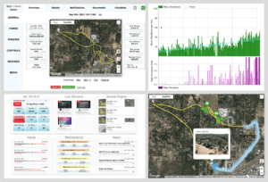
Chula Vista Police Department’s nationally recognized drone program has enlisted the aid of drone fleet management industry leader AirData UAV in order to help provide drone flight transparency to the public. AirData now enables Chula Vista residents to view and understand the exact location, flight path, and purpose behind each police drone deployment.

“Transparency and accountability are key components in the success of our drone programwhich has been an invaluable tool in maintaining the safety of our officers and the public,” said CVPD Chief Roxana Kennedy. “We pride ourselves on ensuring the public has access to our drone flight information in upholding the trust of our community.”

Chula Vista has been a trailblazer in the field since unveiling its Chula Vista PD drone program in October of 2018. The program has since continued to expand its capabilities, and is now providing additional transparency to constituents through the partnership with AirData. The CVPD Drone Program Historical Flight Data is available to view on a dedicated webpage.

AirData supplies CVPD with a simple solution to track and manage all of the flight data from their missions. Officers are able to focus on keeping the community safe with drone technology, while the integration provides effortless data collection and automatic reporting. Federal compliance, reporting, maintenance notifications, and logging are time-intensive tasks, and AirData manages these tasks in the background, allowing police departments to focus on keeping the community safe

“We are excited to work closely with Chula Vista to provide full transparency of the police department flights to the community,” said Eran Steiner, AirData UAV’s Founder and CEO. “AirData enables officers to focus on the community, while AirData performs the mundane and time-consuming work of flight data collection, federal compliance tracking, and crash prevention through tracking drone health. Chula Vista offers its residents an open AirData-driven web page, enabling the public to be well informed of drone-related law enforcement activity.”

AirData UAV provides a robust integration for departments seeking to benefit from a comprehensive Drone as First Responder (DFR) program. Communities benefit greatly when using DFR callouts by saving lives, reducing response times, and saving tax dollars while increasing citizen and officer safety.

Ian attended Dominican University of California, where he received a BA in English in 2019. With a lifelong passion for writing and storytelling and a keen interest in technology, he is now contributing to DroneLife as a staff writer


Miriam McNabb

Miriam McNabb is the Editor-in-Chief of DRONELIFE and CEO of JobForDrones, a professional drone services marketplace, and a fascinated observer of the emerging drone industry and the regulatory environment for drones. Miriam has penned over 3,000 articles focused on the commercial drone space and is an international speaker and recognized figure in the industry.  Miriam has a degree from the University of Chicago and over 20 years of experience in high tech sales and marketing for new technologies.
For drone industry consulting or writing, Email Miriam.

TWITTER:@spaldingbarker

Subscribe to DroneLife here.

Filed Under: Drone News Feeds, News Tagged With: AirData, Chula Vista, drones as first responder, Police Drones

Reader Interactions

Trackbacks

  1. पुलिस कैसे ड्रोन का उपयोग करती है, इस पर एक आंतरिक नज़र: फोर्ट वेन, इंडियाना India January 2022 - Visit हिन्दी मे says:
    January 30, 2022 at 3:06 am

    […] […]

    Reply
  2. Un aperçu de l'utilisation des Drones par la police: Fort Wayne, Indiana - Askell Drone says:
    January 26, 2022 at 2:56 am

    […] savoir plus sur Les drones comme Premiers intervenants, Drones de l’équipe BRINC Swat, et drones pour la lutte contre les […]

    Reply
  3. An Inside Look at How Police Use Drones Ft. Wayne » CDP Aerial Surveys says:
    January 25, 2022 at 6:23 pm

    […] more about Drones as First Responder, BRINC Swat Team drones, and drones for […]

    Reply
  4. An Inside Look at How Police Use Drones Ft. Wayne - AXXvac iPro says:
    January 25, 2022 at 6:17 pm

    […] more about Drones as First Responder, BRINC Swat Team drones, and drones for […]

    Reply
  5. An Inside Take A Look At How Police Use Drones Ft. Wayne says:
    January 25, 2022 at 2:17 pm

    […] Learn extra about Drones as First Responder, […]

    Reply
  6. Un aperçu de l'utilisation des Drones par la police: Fort Wayne, Indiana | Prestations drones, films institutionnels, journal en ligne says:
    January 25, 2022 at 2:07 pm

    […] savoir plus sur Les drones comme Premiers intervenants, Drones de l'équipe BRINC Swat, et drones pour la lutte contre les […]

    Reply
  7. An Inside Look at How Police Use Drones Ft. Wayne | Dagold News says:
    January 25, 2022 at 12:20 pm

    […] more about Drones as First Responder, BRINC Swat Team drones, and drones for […]

    Reply
  8. An Inside Take a look at How Police Use Drones: Fort Wayne, Indiana - Bients says:
    January 25, 2022 at 12:05 pm

    […] extra about Drones as First Responder, BRINC Swat Group drones, and drones for […]

    Reply
  9. Chula Vista PD drone program implements AirData – Dronestagram Blog says:
    October 8, 2021 at 1:21 am

    […] More… […]

    Reply
  10. Chula Vista PD drone program implements AirData – Game Up News says:
    October 7, 2021 at 1:28 pm

    […] Source link […]

    Reply

Leave a Reply Cancel reply

Your email address will not be published. Required fields are marked *

Primary Sidebar

LATEST

FCC Proposes New Spectrum Rules to Advance Air Mobility Technologies

Updated Guidelines Aim to Enhance Safety, Innovation, and Growth in Crewed and Uncrewed Aviation The Federal Communications Commission (FCC) has…

Continue Reading FCC Proposes New Spectrum Rules to Advance Air Mobility Technologies

DJI Expands Beyond Drones with New Super-Fast Chargers for Power Storage Systems

Innovative car and solar chargers join the DJI Power Series, offering solutions for RVs, vehicles, and emergency backup systems. by…

Continue Reading DJI Expands Beyond Drones with New Super-Fast Chargers for Power Storage Systems

Windracers Introduces ULTRA MK2 Cargo UAV: More Power, Payload, and Efficiency

A New Chapter for Autonomous Middle-Mile Logistics Windracers has unveiled its latest self-flying cargo aircraft, the ULTRA MK2, at a…

Continue Reading Windracers Introduces ULTRA MK2 Cargo UAV: More Power, Payload, and Efficiency

Inside Ascent AeroSystems: A Revolutionary Approach to Drones

Coaxial Innovation from Massachusetts Massachusetts-based Ascent AeroSystems offers something unique in the crowded drone market. During a recent visit to…

Continue Reading Inside Ascent AeroSystems: A Revolutionary Approach to Drones

Hempstead Police Department Introduces Drone-As-First-Responder System from Flock Safety

New Technology Aims to Enhance Emergency Response Times The Hempstead Police Department announced plans to deploy a new Drone-as-First-Responder (DFR)…

Continue Reading Hempstead Police Department Introduces Drone-As-First-Responder System from Flock Safety

SkySwap Program: A New Path for Public Safety Drone Compliance

Axon Introduces Drone Swap Program to Help Agencies Transition to Secure, American-Made Drone Technology Public safety agencies in the U.S.…

Continue Reading SkySwap Program: A New Path for Public Safety Drone Compliance

Pioneering the Skies: UAE Approves First Commercial Vertiport for Air Taxis

Dubai’s DXV Facility Sets the Stage for Advanced Air Mobility with Skyports and GCAA’s Vision for Urban Transport Transformation by…

Continue Reading Pioneering the Skies: UAE Approves First Commercial Vertiport for Air Taxis

Drone Nerds Expands Support for American Farmers with ABZ Innovation Partnership

Collaboration Brings Advanced Agriculture Drones to U.S. Market Drone Nerds, a leading provider of enterprise and agricultural drones, has partnered…

Continue Reading Drone Nerds Expands Support for American Farmers with ABZ Innovation Partnership

Closing the Gaps: Why Low-Altitude Airspace Awareness Is Critical for the Future of Aviation

The recent New Jersey drone panic has made it clear: people want to know what’s flying in low altitude airspace.…

Continue Reading Closing the Gaps: Why Low-Altitude Airspace Awareness Is Critical for the Future of Aviation

Addressing Noise Concerns: A Key to Community Acceptance of Drone Delivery Technology

DEXA’s NEPA Testing Highlights Noise Mitigation and Environmental Responsibilit Noise is a major concern for consumers and a critical factor…

Continue Reading Addressing Noise Concerns: A Key to Community Acceptance of Drone Delivery Technology

Secondary Sidebar

Footer

SPONSORED

Inspired Flight Gremsy IF800 VIO F1 drones geo week

What Will It Take to Strengthen U.S. Drone Manufacturing? A Conversation with Inspired Flight’s CEO

Global Mapper Mobile data collection

Collection Ground Control Points with Global Mapper Mobile

Military Drone Mapping Solutions

How SimActive’s Correlator3D™ is Revolutionizing Military Mapping: An Exclusive Interview with CEO Philippe Simard

Photogrammetry Accuracy Standards

SimActive Photogrammetry Software: Enabling Users to Meet Accuracy Standards for Over 20 Years

NACT Engineering Parrot ANAFI tether indoor shot

Smart Tether for Parrot ANAFI USA from NACT Engineering

Blue Marble, features global mapper, features Blue Marble

Check Out These New Features in Global Mapper v25 from Blue Marble

About Us | Contact Us | Advertise With Us | Write for Us | Privacy Policy | Terms of Service

The Trusted Source for the Business of Drones.

This website uses cookies and third party services. By clicking OK, you are agreeing to our privacy policy. ACCEPT

Manage consent

Privacy Overview

This website uses cookies to improve your experience while you navigate through the website. Out of these, the cookies that are categorized as necessary are stored on your browser as they are essential for the working of basic functionalities of the website. We also use third-party cookies that help us analyze and understand how you use this website. These cookies will be stored in your browser only with your consent. You also have the option to opt-out of these cookies. But opting out of some of these cookies may affect your browsing experience.
Necessary
Always Enabled
Necessary cookies are absolutely essential for the website to function properly. These cookies ensure basic functionalities and security features of the website, anonymously.
CookieDurationDescription
cookielawinfo-checkbox-analytics11 monthsThis cookie is set by GDPR Cookie Consent plugin. The cookie is used to store the user consent for the cookies in the category "Analytics".
cookielawinfo-checkbox-functional11 monthsThe cookie is set by GDPR cookie consent to record the user consent for the cookies in the category "Functional".
cookielawinfo-checkbox-necessary11 monthsThis cookie is set by GDPR Cookie Consent plugin. The cookies is used to store the user consent for the cookies in the category "Necessary".
cookielawinfo-checkbox-others11 monthsThis cookie is set by GDPR Cookie Consent plugin. The cookie is used to store the user consent for the cookies in the category "Other.
cookielawinfo-checkbox-performance11 monthsThis cookie is set by GDPR Cookie Consent plugin. The cookie is used to store the user consent for the cookies in the category "Performance".
viewed_cookie_policy11 monthsThe cookie is set by the GDPR Cookie Consent plugin and is used to store whether or not user has consented to the use of cookies. It does not store any personal data.
Functional
Functional cookies help to perform certain functionalities like sharing the content of the website on social media platforms, collect feedbacks, and other third-party features.
Performance
Performance cookies are used to understand and analyze the key performance indexes of the website which helps in delivering a better user experience for the visitors.
Analytics
Analytical cookies are used to understand how visitors interact with the website. These cookies help provide information on metrics the number of visitors, bounce rate, traffic source, etc.
Advertisement
Advertisement cookies are used to provide visitors with relevant ads and marketing campaigns. These cookies track visitors across websites and collect information to provide customized ads.
Others
Other uncategorized cookies are those that are being analyzed and have not been classified into a category as yet.
SAVE & ACCEPT