 Comparing Drones and Satellites for Utility Grid Inspections
DRONELIFE presents this guest post by Kaitlyn Albertoli, the Co-Founder and CEO of Buzz Solutions. Buzz Solutions safeguards the world’s energy infrastructure with an AI-powered predictive analytics platform for visual infrastructure inspections. The company enables field teams to prioritize and perform maintenance in a timely manner reducing the likelihood of wildfires, forced shutdowns, and power outages resulting from failed grid infrastructure. DRONELIFE neither accepts nor makes payment for guest posts.
by Kaitlyn Albertoli, CEO and Co-Founder of Buzz Solutions
Those who work in the utilities sector seem to have a unique understanding of risk – after all, it’s in their nature. From floods, blizzards, hurricanes, wildfires, and heatwaves, to birds, rodents, rot, and rust, it’s brutal out there for utilities, not to mention costly. Utility vegetation management (UVM) is one of the largest expenses for T&D companies, and Accenture estimates that utilities spend “around $6 billion to $8 billion annually on clearing vegetation from overhead lines.” (You know it’s a difficult industry when even rapid growth is a problem.)
To ward off these unrelenting threats, utilities require extensive grid inspection to ensure the safety/operability of their vital (and expensive) assets. That process has improved dramatically over the years, evolving from ground and helicopter-based manual observation done by humans to remote/autonomous inspection by advanced technology like satellites and aerial vehicles (drones, fixed-wing, helicopters, etc.). And now with even more powerful artificial intelligence (AI) and machine learning (ML) tools, analysis that once took months can now be done in a matter of hours or days.
SATELLITES VS. AERIAL VEHICLES: BENEFITS & LIMITATIONS
As innovation exploded during the past decade, so too did energy costs, cybersecurity threats, and the overall strain put on our power grids. Utilities face so much attention and scrutiny from customers and regulators that the noise can seem overwhelming and deafening. Any improvement or digitization of a utility’s operations is net good for the industry and the public, but companies don’t have unlimited funds to accomplish these operational improvements. When it comes to grid inspections, utilities now have options of using satellites or aerial vehicles to monitor their infrastructure, so many utilities must decide which type of data collection method to invest in based on impact.
To be clear, this isn’t a “one or the other” scenario – both satellites and aerial vehicles have unique applications and value depending on a utility’s circumstance and budget, and each improves the overall workflow and productivity of the human technician, while also reducing insurance costs and safety risks. To understand where it’s best to apply satellites versus drones, let’s explore some additional benefits and limitations of satellites and aerial vehicles.
Satellites: Benefits & Limitations
According to the US Energy Information Administration (EIA), there are more than 700,000 miles of circuit transmission lines and 5,000,000 miles of distribution lines in our domestic electric grid. That’s a lot of territory to cover, and industry experts have found that “satellite imagery provides accurate, granular details about the status of a given plot of land, including the current biodiversity and carbon sequestration on the land in plants that would otherwise have been extremely difficult to measure.”
Given their ability to map huge areas and provide a comprehensive overview of a utility’s power line network, satellites have some key benefits over other popular aerial vehicles like drones, including:
-
Satellites can often gather and present data instantaneously given there are even existing maps already available in the public domain
-
No need for any pilot certification or federal/state oversight (which saves time and money compared to the regulatory hurdles that come with drones.)
-
Robust mapping capabilities (which can be applied to vegetation management or powerline inspections and “save weeks of work in the field by eliminating the frequent land surveys that are currently performed manually”)
But satellites also come with some key limitations that may not be immediately evident to utilities, including:
-
Poor photo quality/resolution which may not meet inspection standards (drones have better accuracy, the resolution is much sharper, and utilities can get closer to the actual items they’re inspecting)
-
Significant lag time on acquiring imagery (tasking satellites can take several months to a year, which means utilities have to wait to receive results that they can analyze, during which time conditions on the ground could have changed)
-
Limited sunlight and reduced timeframe when trees have all their leaves (satellites get one trip around the Earth and are limited by night darkness, and it’s also important to monitor when trees are fully-leafed as satellite data is most commonly used for vegetation management)
-
Clouds obscure land views from space (and areas that receive a lot of rain can impact image quality)
-
Less future-proof, customizable tech (as innovation advances on Earth, satellites can’t be retrofitted in real time, making it difficult to provide any bespoke capabilities for utilities as they seek more precise data)
Aerial Vehicles: Benefits & Limitations
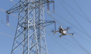
While satellites are most often used for UVM, aerial vehicles like drones are equipped for better accuracy and resolution, lending themselves more useful for things like asset management and overseeing powerlines, transformers, substations, generators, and other equipment necessary for T&D. Industry experts have credited drones for their ability to “enhance the productivity and range of inspection crews by order of magnitude, boosting coverage, volume, and quality of data capture.” Globally, drone usage in the energy industry is expected to reach $6 billion by 2026.
The biggest excitement around drones nowadays comes from their innate coupling with powerful AI capabilities that can provide effective data analysis, swift fault detection, and prioritized predictive maintenance to maximize a utility’s time and cost savings. Other benefits of aerial vehicles over satellites include:
-
Less lag time for critical image results (for example, dry trees can create fire hazards that must be addressed immediately, not when a satellite company queue finally opens. Time is of the essence in a post-storm power restoration environment and drones serve as the perfect tool for data collection.)
-
More control of operations (when a utility builds an in-house drone program, they maintain full autonomy for their data collection and scaling of their inspection program)
-
Long-term sustainability (drones can be manufactured and deployed fast, providing utilities with a cheaper, more agile alternative than satellites)
-
Wider range of capabilities and greater ROI (drones can do everything satellites can do, including accurate vegetation management using new LIDAR sensors, and helicopters provide long-range travel capabilities to remote or inaccessible locations, along with the ability to lift, position, and install heavy equipment)
-
Lengthier history of service (drones, helicopters, and fixed wing have been used in the utilities industry longer than satellites, which results in less of a learning curve for teams)
-
Reduced costs (satellites can average around $60-$90 per line mile, while aerial vehicles offer far more cost-efficiency and agility)
While the benefits of aerial vehicles are clear, there are some limitations that are the inverse of satellite advantages, including:
-
Cost/time of pilot training, regulatory standards, and oversight (there are regulations for commercial drone operators, requiring them to obtain a remote pilot license, adhere to altitude and airspace restrictions, and conduct flights within visual line of sight, among other stipulations)
-
Limited battery life (drones average around 60-90 minutes, while satellites operate constantly. However, new drone-in-the-box technology is overcoming this challenge)
-
Limited scale (while aerial vehicles can map wide areas, satellites are more effective at capturing the total range of utility assets, as well as the biodiversity of a territory)
CLEAR SKIES AHEAD
While the responsibility of maintaining expansive power grids can be stressful, it’s also an incredibly exciting time for utilities. Emerging drone-in-the-box systems, which allow drones to deploy autonomously from a central location, operate a pre-programmed list of commands, and then return to their home base for data upload and charging, are mitigating the limitations of drone programs.
The ongoing wave of innovation will surely bring greater capabilities and efficiencies to the industry, which will ease some of the pressures for utilities as they continue their digitalization journey. Technologies including drone-in-the-box and full beyond visual line of sight (BVLOS) clearances will allow for more cost-effective, time-efficient, and scaling inspection programs.
As utility decision makers evaluate their options, it’s important to remember the complementary relationship between satellites and aerial vehicles. By staying informed and curious about advancements in both fields, utilities will ensure they’re equipped with the right solutions to ensure the long-term viability of their assets.
Read more:
- Drones for Utilities: How AI is Redefining Utility Inspections
- DRONEII: Drone Industry Investment and Growth, from the Floor of Energy Drones and Robotics Summit
- Australian First: Carbonix Partners with SA Power for BVLOS Powerline Inspection
 Kaitlyn Albertoli is CEO and co-founder of Buzz Solutions. Prior to founding Buzz Solutions with her co-founder Vik Chaudhry in 2017, Kaitlyn ran a non-profit focused on sustainable food with 60 people overseeing the needs of 300 people. She was previously a wealth management analyst at JP Morgan Chase. Kaitlyn was named to Forbes 30 under 30 in 2021. She studied international relations and finance at Stanford University, where she received her B.A.

Miriam McNabb is the Editor-in-Chief of DRONELIFE and CEO of JobForDrones, a professional drone services marketplace, and a fascinated observer of the emerging drone industry and the regulatory environment for drones. Miriam has penned over 3,000 articles focused on the commercial drone space and is an international speaker and recognized figure in the industry. Miriam has a degree from the University of Chicago and over 20 years of experience in high tech sales and marketing for new technologies.
For drone industry consulting or writing, Email Miriam.
TWITTER:@spaldingbarker
Subscribe to DroneLife here.


[…] Supply hyperlink […]