• Skip to main content
  • Skip to secondary menu
  • Skip to primary sidebar
  • Skip to secondary sidebar
  • Skip to footer
  • DroneRacingLife
  • DroneFlyers
  • Newsletter
DroneLife

DRONELIFE

Stay up to date on all the latest Drone News

  • News
  • Products
  • Industries
    • Agriculture
    • Construction
    • Delivery
    • Dual Use
    • Inspection
    • Public Safety
    • Surveying
  • Enthusiasts
  • Regulations
  • Business
  • Video
  • Podcasts

Wingtra Introduces Advanced LIDAR Drone Solution for Precision Mapping

February 12, 2024 by Miriam McNabb 4 Comments

Wingtra LiDARWingtra Unveils LIDAR Drone Solution, Transforming Aerial Mapping

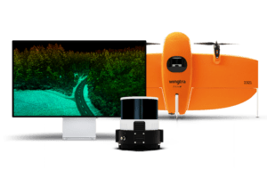
Wingtra is a leading drone technology company specializing in the development and manufacturing of high-end drone solutions.  Today, Wingtra has announced the launch of its groundbreaking LIDAR drone solution, marking a significant leap forward in drone-based LIDAR technology. The new Wingtra LIDAR payload seamlessly combines the efficiency, operational simplicity, and unrivaled precision of the WingtraOne GEN II drones with an advanced Wingtra-engineered LIDAR sensor, establishing a new industry standard.

Julian Mackern, Product Manager at Wingtra, expressed his enthusiasm: “We’re excited to deliver a LIDAR drone mapping solution to our customers, which we’re confident will exceed their expectations, cut their costs and headaches, and win them more bids. We’re already seeing our first customers comment how surprisingly easy it is to set up, fly and generate a high-quality point cloud. And as always, we keep our promise with the data: high-precision, reliable and repeatable.”

Wingtra’s innovative solution has already garnered global attention, with customers across diverse sectors embracing the WingtraOne GEN II for its efficient, secure, and frequent mapping capabilities, facilitating photogrammetric analysis of various worksites. The integration of the meticulously crafted LIDAR payload offers a comprehensive solution, spanning the entire project lifecycle from inception to execution and ongoing maintenance.

By incorporating a state-of-the-art Hesai scanner, Inertial Labs IMU, and NovAtel GNSS, Wingtra LIDAR substantially reduces the need for labor-intensive post-processing strip alignment, providing precise terrain data immediately following each efficient flight.

Carlos Femmer, Director of Data Acquisition at HDR, shared his experience testing the Wingtra LIDAR payload: “We’re seeing [USGS topographical] quality level zero results on hard surfaces, which are quality results. We were able to test the horizontal and vertical strip alignment quality. We looked at both vegetated areas and non-vegetated areas, and it’s very clean, it aligns well. There’s minimal noise as compared to other LIDAR sensors in this price range and it delivers exceptional overall precision.”

One of the notable advantages of Wingtra LIDAR is its ability to minimize field time, requiring no calibration and initializing in just one minute. The user-friendly Wingtra LIDAR app and automated experience empower users, even novices in LIDAR data capture, to swiftly build confidence, saving at least an hour per survey compared to rival systems.

Leo Liu, Director of Mapping Solutions at Inertial Labs, praised the efficiency of the system: “Wingtra LIDAR capture and processing is super efficient. Technically, if you have everything structured, it’s literally one click and it’s done to get you to that point cloud. In terms of drone LIDAR capture, the goal is that it has to get cheaper and simpler to use. And the good news is that that’s happening with Wingtra.”

Wingtra LIDAR boasts a vertical accuracy of 3 cm (1.2 in), validated by leading customers as top-of-the-line from a flight height of 60 m (200 ft). Its exceptional point density, combined with the WingtraOne GEN II’s design and automated flight patterns, ensure consistency across different pilots.

Femmer further elaborated on the sophistication of LIDAR data capture and the uniqueness of Wingtra’s system: “Wingtra’s automated LIDAR capture is, in my opinion, better than other systems in this price range. I can send three different pilots to the same location and get the same quality result processing on the back end.”

Note: Strip alignment during post-processing on alternative drone LIDAR units typically requires half an hour due to lower-quality IMU performance, resulting in misaligned data capture. This, coupled with initialization and calibration for each flight, drains flight battery and diminishes overall mission efficiency.

Read more:
  • New Payload for Wingtra VTOL Drones: RGB61
  • Wingtra Gives Away Drones for a Good Cause: The Wingtra Earth Day Challenge
  • 3D Drone Mapping Data Capture: WingtraOne GEN II’s Oblique Camera Configuration
Miriam McNabb

Miriam McNabb is the Editor-in-Chief of DRONELIFE and CEO of JobForDrones, a professional drone services marketplace, and a fascinated observer of the emerging drone industry and the regulatory environment for drones. Miriam has penned over 3,000 articles focused on the commercial drone space and is an international speaker and recognized figure in the industry.  Miriam has a degree from the University of Chicago and over 20 years of experience in high tech sales and marketing for new technologies.
For drone industry consulting or writing, Email Miriam.

TWITTER:@spaldingbarker

Subscribe to DroneLife here.

Filed Under: Applications, Drone News, Drone News Feeds, Drones in the News, News Tagged With: HDR+, Intertial Labs, LIDAR, LIDAR capture, mapping drone, mapping with drones, Wingtra

Reader Interactions

Trackbacks

  1. Wingtra LiDAR Launched - DRONELIFE - Hello says:
    February 13, 2024 at 12:10 am

    […] Supply hyperlink […]

    Reply
  2. Wingtra LiDAR Launched - DRONELIFE - Enjbs says:
    February 12, 2024 at 5:36 pm

    […] Supply hyperlink […]

    Reply
  3. Wingtra LiDAR Launched - DRONELIFE - TC Technology News says:
    February 12, 2024 at 5:25 pm

    […] Supply hyperlink […]

    Reply
  4. Wingtra Introduces Advanced LIDAR Drone Solution for Precision Mapping – Independent Drone Exchange says:
    February 12, 2024 at 3:43 pm

    […] post Wingtra Introduces Advanced LIDAR Drone Solution for Precision Mapping appeared first on […]

    Reply

Leave a Reply Cancel reply

Your email address will not be published. Required fields are marked *

Primary Sidebar

LATEST

FCC Proposes New Spectrum Rules to Advance Air Mobility Technologies

Updated Guidelines Aim to Enhance Safety, Innovation, and Growth in Crewed and Uncrewed Aviation The Federal Communications Commission (FCC) has…

Continue Reading FCC Proposes New Spectrum Rules to Advance Air Mobility Technologies

DJI Expands Beyond Drones with New Super-Fast Chargers for Power Storage Systems

Innovative car and solar chargers join the DJI Power Series, offering solutions for RVs, vehicles, and emergency backup systems. by…

Continue Reading DJI Expands Beyond Drones with New Super-Fast Chargers for Power Storage Systems

Windracers Introduces ULTRA MK2 Cargo UAV: More Power, Payload, and Efficiency

A New Chapter for Autonomous Middle-Mile Logistics Windracers has unveiled its latest self-flying cargo aircraft, the ULTRA MK2, at a…

Continue Reading Windracers Introduces ULTRA MK2 Cargo UAV: More Power, Payload, and Efficiency

Inside Ascent AeroSystems: A Revolutionary Approach to Drones

Coaxial Innovation from Massachusetts Massachusetts-based Ascent AeroSystems offers something unique in the crowded drone market. During a recent visit to…

Continue Reading Inside Ascent AeroSystems: A Revolutionary Approach to Drones

Hempstead Police Department Introduces Drone-As-First-Responder System from Flock Safety

New Technology Aims to Enhance Emergency Response Times The Hempstead Police Department announced plans to deploy a new Drone-as-First-Responder (DFR)…

Continue Reading Hempstead Police Department Introduces Drone-As-First-Responder System from Flock Safety

SkySwap Program: A New Path for Public Safety Drone Compliance

Axon Introduces Drone Swap Program to Help Agencies Transition to Secure, American-Made Drone Technology Public safety agencies in the U.S.…

Continue Reading SkySwap Program: A New Path for Public Safety Drone Compliance

Pioneering the Skies: UAE Approves First Commercial Vertiport for Air Taxis

Dubai’s DXV Facility Sets the Stage for Advanced Air Mobility with Skyports and GCAA’s Vision for Urban Transport Transformation by…

Continue Reading Pioneering the Skies: UAE Approves First Commercial Vertiport for Air Taxis

Drone Nerds Expands Support for American Farmers with ABZ Innovation Partnership

Collaboration Brings Advanced Agriculture Drones to U.S. Market Drone Nerds, a leading provider of enterprise and agricultural drones, has partnered…

Continue Reading Drone Nerds Expands Support for American Farmers with ABZ Innovation Partnership

Closing the Gaps: Why Low-Altitude Airspace Awareness Is Critical for the Future of Aviation

The recent New Jersey drone panic has made it clear: people want to know what’s flying in low altitude airspace.…

Continue Reading Closing the Gaps: Why Low-Altitude Airspace Awareness Is Critical for the Future of Aviation

Addressing Noise Concerns: A Key to Community Acceptance of Drone Delivery Technology

DEXA’s NEPA Testing Highlights Noise Mitigation and Environmental Responsibilit Noise is a major concern for consumers and a critical factor…

Continue Reading Addressing Noise Concerns: A Key to Community Acceptance of Drone Delivery Technology

Secondary Sidebar

Footer

SPONSORED

Inspired Flight Gremsy IF800 VIO F1 drones geo week

What Will It Take to Strengthen U.S. Drone Manufacturing? A Conversation with Inspired Flight’s CEO

Global Mapper Mobile data collection

Collection Ground Control Points with Global Mapper Mobile

Military Drone Mapping Solutions

How SimActive’s Correlator3D™ is Revolutionizing Military Mapping: An Exclusive Interview with CEO Philippe Simard

Photogrammetry Accuracy Standards

SimActive Photogrammetry Software: Enabling Users to Meet Accuracy Standards for Over 20 Years

NACT Engineering Parrot ANAFI tether indoor shot

Smart Tether for Parrot ANAFI USA from NACT Engineering

Blue Marble, features global mapper, features Blue Marble

Check Out These New Features in Global Mapper v25 from Blue Marble

About Us | Contact Us | Advertise With Us | Write for Us | Privacy Policy | Terms of Service

The Trusted Source for the Business of Drones.

This website uses cookies and third party services. By clicking OK, you are agreeing to our privacy policy. ACCEPT

Manage consent

Privacy Overview

This website uses cookies to improve your experience while you navigate through the website. Out of these, the cookies that are categorized as necessary are stored on your browser as they are essential for the working of basic functionalities of the website. We also use third-party cookies that help us analyze and understand how you use this website. These cookies will be stored in your browser only with your consent. You also have the option to opt-out of these cookies. But opting out of some of these cookies may affect your browsing experience.
Necessary
Always Enabled
Necessary cookies are absolutely essential for the website to function properly. These cookies ensure basic functionalities and security features of the website, anonymously.
CookieDurationDescription
cookielawinfo-checkbox-analytics11 monthsThis cookie is set by GDPR Cookie Consent plugin. The cookie is used to store the user consent for the cookies in the category "Analytics".
cookielawinfo-checkbox-functional11 monthsThe cookie is set by GDPR cookie consent to record the user consent for the cookies in the category "Functional".
cookielawinfo-checkbox-necessary11 monthsThis cookie is set by GDPR Cookie Consent plugin. The cookies is used to store the user consent for the cookies in the category "Necessary".
cookielawinfo-checkbox-others11 monthsThis cookie is set by GDPR Cookie Consent plugin. The cookie is used to store the user consent for the cookies in the category "Other.
cookielawinfo-checkbox-performance11 monthsThis cookie is set by GDPR Cookie Consent plugin. The cookie is used to store the user consent for the cookies in the category "Performance".
viewed_cookie_policy11 monthsThe cookie is set by the GDPR Cookie Consent plugin and is used to store whether or not user has consented to the use of cookies. It does not store any personal data.
Functional
Functional cookies help to perform certain functionalities like sharing the content of the website on social media platforms, collect feedbacks, and other third-party features.
Performance
Performance cookies are used to understand and analyze the key performance indexes of the website which helps in delivering a better user experience for the visitors.
Analytics
Analytical cookies are used to understand how visitors interact with the website. These cookies help provide information on metrics the number of visitors, bounce rate, traffic source, etc.
Advertisement
Advertisement cookies are used to provide visitors with relevant ads and marketing campaigns. These cookies track visitors across websites and collect information to provide customized ads.
Others
Other uncategorized cookies are those that are being analyzed and have not been classified into a category as yet.
SAVE & ACCEPT